What Would $720 Million for Transportation Buy?
City Council mulls the "Go Big" bond in preparation for the November ballot
By Nick Barbaro, Fri., Aug. 5, 2016


The centerpieces of the proposed Nov. 8 transportation bond – dubbed the "mobility bond" or "Go Big" bond by Mayor Steve Adler – are the seven "smart corridor" projects highlighted here, which have (or will soon have) corridor plans prepared by the Austin Transportation Department. Amid the several versions of the $720 million proposal debated by City Council, funding and projects were moved from other transportation priorities into this section of the package – not only to target completion funding for the seven corridors, but to develop plans for other significant roads (dubbed "future corridors") as well.
The currently proposed funding for current and future corridors is $482 million – two-thirds of the entire $720 million. The remaining funding would be dedicated to six "regional" mobility projects and a miscellany of "local," more "multimodal" projects, to include sidewalks, bicycle lanes and urban trails, and spot improvements like railroad crossings. See more detail on the jump pages. – Michael King
Go Big Corridor Plan – Total Package: $720,000,000
This is the latest tentative project list from the mayor's office. But it's worth noting that, in the ballot language and bond proposition that Council is currently considering, very little of this is actually specified. The regional mobility projects and existing corridor plans are named, but the bond language states only that the money will be spent on projects, including those, attaches no specific dollar amount to any of them, and does not mention any of the specific future corridors and substandard roadways listed below. The Local Mobility money is broken down to the general categories listed below, but with none of the specific substandard roadways identified.

10 Things to Know About the "Go Big" Bond Plan
1) The exact list of projects proposed to be funded has changed somewhat back and forth as the package was being developed, and is now deliberately vague in places. So the list at right isn't really real; it's what the money would probably be spent on if it were all being allocated today, but it's intended to be flexible. As all these projects roll out over the next eight years (or more), conditions may change and, within limits, City Council or the Transportation Department will be able to shift funding around pretty much however they want, within the general funding categories.
2) This lack of specificity is as much a political choice as a policy one.
3) Time is tight. For now, Council is planning to hear public speakers at their Aug. 11 meeting, and will need to pass the ordinance to set the ballot on all three readings at their Aug. 18 meeting, which would require seven votes, in order to meet the Aug. 22 deadline to have the ballot set, and language approved by the state.
4) In some fairly late maneuvering, seven more future corridors are now slated for preliminary engineering reports, and provision was made for one unspecified South Austin corridor to be added to the list of smart corridors, though no funding was added for it. Presumably, that would be one of the four southern corridors – South Congress, William Cannon, Slaughter, or Pleasant Valley – listed as Future Projects.
5) The Trails and Bicycle Master Plans each got a big bump, from $30 million to $50 million combined.
6) This massive plan places a lot of faith in (and pressure on) the Austin Transportation Department. This is a much bigger scope of work than they've managed before, and they anticipate adding 20-25 additional staff to manage that workload.
7) The ATD and Mayor Steve Adler are putting a lot of faith as well into a recent report from Jeffrey Tumlin entitled "Transportation Strategy Recommendations," which contains a number of suggestions for Austin transportation policy. First among them: "Implement Corridor Plans with a Focus on Walkability," and "Strengthen the Partnership between the City and Capital Metro through the Creation of an Austin Transportation Master Plan."
8) ATD is indeed developing the Austin Strategic Mobility Plan, working with Capital Metro. Meanwhile, however, Capital Metro is producing its own Connections 2025 plan, which may or may not work in concert with the ASMP, or with the code revisions being contemplated by the CodeNEXT process (see below). Now, you might ask, in a perfect world, wouldn't we do all that planning first, and use it to inform the bond package, and Cap Met's long-range policy decisions? Or, maybe not.
9) The CodeNEXT team is currently taking input on its third of four Code "Prescriptions" – this one focused on mobility, and how the city can better address transportation issues in the Land Development Code rewrite. See the Mobility Prescription at www.austintexas.gov/codenext.
10) Meanwhile, the Central Austin Community Development Corp. continues to push for Council to place an additional item on the ballot: a 5.3-mile, $400 million light rail starter line in the Guadalupe-North Lamar corridor, running from Downtown to the Crestview Station at Airport Blvd. This week, they released a poll showing support from over 56% of likely voters, and got the endorsement of the Hyde Park Neighborhood Association. They say it's a no-lose scenario for Council to give voters their say; yet it seems unlikely any council member will take them up on it at this late date. – Nick Barbaro
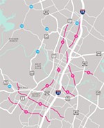
Austin's Corridor Mobility Plans
Two-thirds of the entire bond package – some $477.5 million in all – goes into developing out the seven transit corridors you see on this page. Here's a look at what you're getting for that money.
Why these corridors?
This original list of corridors that are to be developed into smart corridors came from the 2010 transportation bond package (see "Rubber Meets the Road," Oct. 22, 2010), which funded a number of preliminary engineering studies – as this current one will – under the city of Austin Corridor Mobility Development Program. The Austin Transportation Department developed four plans, all completed between Dec. 2013 and Feb. 2014, along with two more – South Lamar and Guadalupe – that were added into the mix later in 2012. But it's worth noting that these are just a few of many projects that got seed funding in that 2010 package. And the only mention of North Lamar/Burnet in the 2010 bond is $10M funding for sidewalks for ADA compliance. Riverside, Airport, and MLK/969 are indeed funded for study, but so are Manchaca and Rundberg.A caveat on costs:
Regarding all of the cost estimates here, a recent memo to Council from Assistant City Manager Robert Goode clarified that the Corridor Reports provided estimates for construction costs only, totaling some $820 million, and not including "project management and delivery, project contingency, bond issuance fees and inflation." Staff estimates the full cost to be close to double that, for a grand total of about $1.5 billion – not including the as-yet unspecified South Austin corridor. So, while the bond as tentatively structured would fully fund the listed cost estimates for the Burnet, North Lamar, Airport, and South Lamar plans, it would actually only fund about half of the total costs. The city would have to look as well to alternative financing from partner entities (such as Travis County, TxDOT, Capital Metro), or from tax money, including perhaps tax increment financing districts.What makes these "smart" corridors?
"So what would we be doing to these old state highways that would turn them into Smart Corridors?" asks a recent press release from the mayor's office. "Everybody gets something, so the roads would better for everyone: pullouts and queue jumps for rapid transit, protected paths for bicycles, sidewalks and safe crosswalks for pedestrians, turn lanes, medians, and access management for vehicles, and smart signals that we can time remotely in response to weather, special events, collisions, etc." Each of the corridor plans is chock-full of such features; see them all at www.austintexas.gov/department/corridor-studies.
North Lamar/Burnet Rd. Corridor Report
N. Lamar Blvd. (from U.S. 183 to I-35); Burnet Rd. (from Koenig to MoPac/Loop 1)Study dated Dec. 2013. Cost estimate: $75.5M for Burnet, $74.3M for Lamar. Proposed funding: $80M and $85M.
Listed as two separate projects, these were studied as a single corridor plan. While the Burnet planning area comes all the way down to Koenig, the work on Lamar doesn't start until north of U.S. 183. As such, this project wouldn't touch any of what most people think of as the North Lamar corridor – from south of the river all the way up to U.S. 183 – that area is considered a "future corridor," funded only for a preliminary engineering report.
For both projects, fully two-thirds of the cost is in drainage improvements and roadway reconstruction to completely rebuild these two streets with medians and transit lanes for these two northern routes for Capital Metro's MetroRapid bus service. The envisioned short-term projects would take a combined $80M or so, and would include completion of "pilot projects" on each road: complete reconstruction from Rundberg to Braker and from Koenig to Anderson.

Airport Boulevard Corridor Report
Airport Blvd. (from N. Lamar to U.S. 183)Study dated Feb. 2014. Cost estimate: $74.4M. Proposed funding: $75M.
This ambitious plan would rehab the entire length of this great diagonal corridor that runs through a number of distinctive streetscapes: From Crestview Station at North Lamar, to ACC's new Highland Mall development and the growing Travis County offices complex, to Mueller's southwest edge, to the long commercial stretch south of MLK, it's a thoroughfare that transects and connects a variety of land uses and income levels. As with Lamar/Burnet, this plan is probably about half-funded by the proposed bond, but with multiple rail stops, current and future "transit-oriented developments," and multiple institutional landowners, it probably has more potential funding partners. See "Preparing for Takeoff," Oct. 21, 2011, for a detailed look at the Upper Airport Boulevard Redevelopment Initiative, which informed much of the later corridor report.

South Lamar Corridor Report
S. Lamar Blvd. (from Riverside Dr. to Ben White Blvd.)Study dated April 2016. Cost estimate: $60.4M. Proposed funding: $60M.
Since this study was just completed, its cost estimates are perhaps a bit more up-to-date, but like Airport, Lamar, and Burnet, it's still probably only about half-funded under the current bond scheme. Included in the $20.4M short-term cost is a completely new cross-section between Riverside and Treadwell, as well as more incremental fixes along the entire length down to Ben White Blvd. It was a late addition to the smart corridor wannabes, but traffic analyses indicate it would have the most immediate impact on commuting delays.

East Riverside Corridor Report
E. Riverside Dr. (from I-35 to SH 71)Study dated Dec. 2013. Cost estimate: $358M long-term, but that includes high-capacity transit. Proposed funding: $83M.
Short-term improvements total just $2.2M, for myriad improvements to intersections, sidewalks, bike lanes, medians, and driveways. The recommended long-term improvements "are meant to change the overall physical operation of the corridor and be constructed with the planning horizon year 2025." These include reducing travel lanes in each direction, building a 7- to 8-foot cycle track in both directions that is buffered from the roadway and sidewalk, and re-grading for "center running high capacity transit that is assumed to extend from west of IH 35 to SH 71." (This was the most preferred corridor in the 2014 Project Connect rail plan.) The proposed $83M would probably fund all of the roadway improvements in the plan; the rest (88%) appears to be rail-related, and may not be relevant anymore (for now).

MLK/FM 969 corridor Report
E. Martin Luther King Jr. Blvd./FM 969 (from U.S. 183 to Webberville)Study dated Feb. 2014. Cost estimate: $111.2M. Proposed funding: $40M.
This project area runs east from U.S. 183, all the way out to the town of Webberville (about two-thirds of it is outside the Austin city limits). Short-term costs, however, total just $7.8M, and are concentrated in bike and pedestrian projects, and in the close-in area inside the Austin city limits. And $93.2M of the long-term total is for major arterial improvements that require major right-of-way acquisitions – $33.7M to widen Hunters Bend to Webberville, and $59.5M for 969 between 183 and SH 130 – so it's unclear what the proposed bond funding of $40M is meant to do here. Meanwhile, as with North Lamar, the closer-in, more-congested part of the corridor – MLK from U.S. 183 to I-35 – is slated for study as a future corridor.

Guadalupe Corridor Improvement Program
Guadalupe St. (from MLK north to 29th, and from Rio Grande St. to a block east into the UT-Austin campus)Study not yet completed. No cost estimate. Proposed funding: $60M.
This study is ongoing, with the Transportation Department having just finished the public feedback part of the process. There are currently four options in play, but all of them envision converting Nueces/San Antonio St. into a two-way corridor, and possibly moving bus lanes there. (Ironically, this is similar to a proposal making the rounds two years ago that was meant to facilitate light rail in this bottleneck.) All options would also move bicycle lanes off of Guadalupe in the problematic, narrow, bendy stretch just below 29th St.: southbound bikes would veer onto Nueces at 29th (behind Dirty's) and return to Guadalupe at 25th; northbound riders would jog right at 27th onto Hemphill Park, then come back to Guadalupe on 29th.
Unspecified South Austin Corridor
Complaints from the south-of-the-river council members led to the promised "implementation of a South Austin corridor," though there is not yet any indication of where that might be, or what money might be available for it. With nurturing, this could become the city equivalent of AISD's long-awaited "New South Austin High School" – on the shelf ever since voters approved money for land purchase in 2008. – Nick Barbaro
See all of the city's corridor plans at www.austintexas.gov/department/corridor-studies.
Got something to say on the subject? Send a letter to the editor.