Land for Water
The city is asking voters to send more money to a little-known program that protects Barton Springs
By Lindsay Stafford Mader, Fri., Oct. 26, 2018


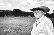
On a warm August morning, I stand in the dry bed of Onion Creek in Hays County and watch as Kevin Thuesen lowers himself into a hole in the earth. I pay attention when he stresses having three points of contact at all times because I'll soon be following him into this small cave. Thuesen, a land manager for Austin Water Utility who loves to tell jokes and talk hydrology, has invited me along for a day of spelunking and hiking to illustrate the somewhat counterintuitive concept behind the utility's Water Quality Protection Lands – namely that Barton Springs, 20 miles away, depends on these city-owned properties full of caves, pores, and conduits. "What you put in here," he says, "is what you get out in Barton Springs."
The city created the little-known WQPL program 20 years ago with the passage of a $65 million bond that was used to buy land above the segment of the Edwards Aquifer that flows to Barton Springs. With four additional voter-approved bonds totaling more than $155 million, the program now preserves and manages almost 30,000 wild acres, in both Hays and Travis counties, for the purpose of sending more water and higher-quality water to Austin's most beloved natural feature. By keeping this land undeveloped, the city aims to reduce the amount of impervious cover that blocks connections to the aquifer and to decrease pesticides, petroleum and automobile runoff, and other pollutants entering the aquifer. And, this November, the city will ask for another $72 million to spend on acquiring new land before it's consumed by the inevitable force of sprawl.
Thuesen, who manages the WQPL program, has started our journey on land that is home to a sensitive stretch of Onion Creek that, during an average year, can send about 4 billion gallons of water to the aquifer and on to the springs. The expanse is a pristine prairie savanna, with wide views of grassland browned from the summer, a few oaks, and subtle hills. As Thuesen likes to put it, "All this will never become Pflugerville." At the cave in the creek bed, he tells me that it and others like it are probably hundreds of thousands of years old, just some of many Balcones Fault fractures that have been dissolved and hollowed out by water. And, he adds, the cave's farthest chamber has had fewer visitors than the moon. A rope ladder, only eight or so inches wide, dangles into the mouth of the cave (to my surprise, there are no harnesses). Wearing helmets and head lamps, we descend by gripping what we can of the ladder and vertical side walls made of calcite and silica.
Thirty-five cautiously traversed feet down, we reach the bottom room, which is a little larger than a car trunk. When the creek is flowing (today it isn't), water spills into these caves. Thuesen points to a small gap in a pile of rocks, which is blocking us from going farther, and explains that the water will continue through this crack and into the aquifer and, in just a few days, will arrive at the Soul of the City. "It's not conventional wisdom that says you should go 20 miles away on the edge of the section of the aquifer, and that this would be your most productive segment," he explains. "Most people say, 'If you want to protect Barton Springs, what about Zilker Park?' And we're like, 'Actually, the most important stuff is a long ways away.'"
A Wild Idea
The Eighties and Nineties were a busy time for Austin development and environmental activism, and it was out of this conflict that the WQPL program was born. "As our demographics change, people don't know all the fights that went on about Barton Springs," Thuesen says while driving to the next stop on our tour. "A lot of people go there and just take it somewhat for granted – you know, it's always been here, it's always going to be here. But we spent $155 million to make sure of that."
The Barton Creek Square mall, over 1 million square feet, was constructed in 1981, and during that year Barton Springs Pool closed more than 30 times due to polluted water. One year later, real estate developer Gary Bradley started on his huge Circle C subdivision, parts of which were located over one of the Edwards Aquifer's most sensitive recharge regions. Then, global mining giant Freeport-McMoRan sought to build thousands of residences and multiple golf courses on 4,000 acres upstream of Barton Creek. In a scenario that seems impossible for today's distracted society, as many as 800 people showed up at the June 7, 1990, City Council meeting, almost all of them to speak out against the plans that they feared would degrade the springs. "Austin was a different place at that time," recalls Bill Bunch, executive director of the Save Our Springs Alliance. "There was more of a citizen community and public engagement." At about 6am, Council voted unanimously to reject Freeport's proposal, wrapping up what has been described as one of our city's most defining moments.

Council soon passed a strong water quality ordinance for the Barton Springs Zone of the aquifer, but the next Council watered it down. So a coalition of organizations urged voters to petition for an election on an enhanced ordinance. They got enough signatures, the item was placed on the ballot, and the Save Our Springs Ordinance passed easily in August of 1992. But, true to form, the Texas Legislature had other ideas and passed a bill that grandfathered all plats filed before the ordinance was passed (including the Freeport development), exempting them from the new regulations. Bunch estimates that this reduced the ordinance's reach to about 10-20% of what it should have covered, and that some of the grandfathered plats are still around today.
The state's move did not stymie Austin environmentalists, who won a majority of seats on City Council in 1996. Chronicle alumnus Daryl Slusher was one of the new council members and was instrumental in the genesis of the WQPL program. By this point, Slusher says, the city knew it wanted to preserve the faraway land because the Watershed Protection Department had done studies and dye traces establishing that the Slaughter, Bear, and Onion Creek watersheds were essential to the health of Barton Springs.
Because the then-operational Green Water Treatment Plant across from Barton Springs was sending some water into the city's drinking supply, Slusher proposed that the land be purchased with a utility bond, and thus not have to compete with general-fund needs. Then-Mayor Kirk Watson brokered a peace agreement between the environmentalists and the business community by putting the WQPL funds on the ballot along with a bond for a Convention Center extension. Most council members campaigned in support of what the city has long called its "wild idea" of purchasing land to preserve its resources as opposed to regulating development. The bond passed with 53% of the vote.
The early years of the program, led by Thuesen's predecessor Willy Conrad, were spent purchasing land and setting up a strategy for management and public access. User groups wanted a range of uses, from absolutely none to putting in soccer fields and housing for the homeless. A compromise was eventually reached that it would be limited and intentional – the program was under the Water Utility and not Parks and Recreation, after all – and that the organizations, not the utility, would plan, build, operate, and maintain the trails. The Water Utility had also started looking at land to purchase using a matrix of sensitive properties assembled by Watershed Protection. Some land was bought outright, where the city fully owns it, and some was purchased through conservation easements, where the city pays the landowner about 50% of the property's value to own the development rights. This, Slusher says, allowed the city to stretch its funds and the families to retain their ranches and heritage while also making some money. The first WQPL conservation easement came from Ira Yates, whose mother previously sold part of the family ranch for Bradley's Circle C project.
Native State
If you've swum in Barton Springs Pool during the early morning, especially if it hasn't recently rained, you likely found yourself stunned by how pure and clean the water seems. According to Bunch, the springs generally still have, under base flow conditions, very low levels of human toxins. But two important pollutants that are harmful to aquatic life, including the endangered Barton Springs salamander, are increasing. This includes nitrogen and phosphorus, which Bunch says largely come from wastewater plants in the watershed and trigger the growth of nuisance algae that, when dying off, increase bacteria that consume oxygen and impact what plant and animal species can thrive and survive. Other harmful substances include petroleum hydrocarbons, pesticides, and heavy metals. "We're basically in a race," Bunch says. "More development means more pollution. The springs are still pretty high-quality because a whole lot of the watershed is still undeveloped. So the future of the springs is still up for grabs and largely rests on how much of that remaining undeveloped watershed is preserved versus how much is developed."
The WQPLs currently consist of just over 28,000 acres, 38% of which is fee simple (owned outright by the city) and 62% of which is conservation easements. It's not easy to acquire land in the Hill Country for the purpose of keeping it wild: 60% of the Barton Springs Zone is already developed, but this means that 40% is potential acreage for preservation. Some of this has already sold to developers, some of whom likely have grandfathered plats. So the WQPL program must find developers and other landowners who, as Thuesen says, want to "conserve their land in perpetuity." Then, the process of gaining landowners' trust and negotiating can take several years. Still, he says, this work is rewarding. "It has really changed my outlook on the world – both work colleagues and landowners are willing to give so much to protect a natural feature for citizens who may never know their names or roles. And quite literally for citizens not born yet."

Even when the program has successfully purchased land to protect, there are often larger forces at play. Take the State Highway 45 toll road, which is being extended to FM 1626 near Manchaca. On our tour, Thuesen takes me to the program's Upper Bear Creek Management Unit to point out where this freeway is now dissecting WQPL. We pass through what is called a wildland-urban interface, with the orderly Shady Hollow subdivision on one side and the WQPL, full of prickly pear and coyotes, on the other. Eventually the sight of SH-45 emerges, huge and imposing, and I can't help but hear Cat Stevens singing in my head. Thuesen says they weren't fans of the road because of all the WQPLs this property has the densest collection of caves, sinkholes, and other karst features. The city had already agreed to sell the right of way to TxDOT, so his staff aimed to get the best environmental protections. To some surprise, Thuesen says the project ended up being more environmentally conscious than expected. But because the Public Utility Commission of Texas required a power line next to the highway, the land is strewn with huge towers, each with a borehole about 20 feet deep and 10 feet wide. And these crisscross the freeway to avoid large caves. "In the next 20 to 50 to 100 years," Thuesen explains, "[the land's focus] is going to be how do we keep it from getting dissected by power lines, cable lines, gas lines, highways. Pretty soon you end up with a piece of land that is cut up into all these pieces. That's not as good for water."
In addition to preventing development, the WQPL program does considerable land management with its three full-time employees, 11 part-time employees (who also work on the Balcones Canyonland Preserve), and total annual budget of around $1.6 million. An important part of this is excavating sediment from existing and newly discovered caves so that water can flow unimpeded. The caves are located by looking for circular depressions in the ground where green plants are growing or by asking landowners if they ever noticed whirlpools on their ranches. Initial excavation can be lengthy, sometimes taking up to a decade, because all rocks and sediment – which they estimate have been deposited relatively recently – are removed through five-gallon buckets (and sometimes the caves are full of water and inaccessible). Big steel grates are then placed over the entrances to caves, and these are periodically cleaned off to keep an optimal amount of water going in. Thuesen jokes that his wife says, "It's like a hair catcher at the bottom of a tub."
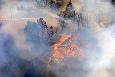
Above ground, staff work on restoring ecosystems back to their "ideal native states." Thuesen drives me to the Mary Gay Maxwell Management Unit, where Slaughter Creek is, to show me what "the Hill Country is supposed to look like." We pick up WQPL biologist Matt McCaw and head up a hill to get a view of 682 acres of grassland, with a few Circle C rooftops in the distance. Standing in the blistering August sun, McCaw explains that some of the lands come to them as overgrazed pastures with juniper (cedar) and brush encroaching. Cedar is an infamous water-sucker, and McCaw says that when soil has been compacted by cattle hooves, water cannot be easily absorbed below ground. So staff light fires on the land to kill off cedar and brush and put nutrients back into the soil, something that used to be done naturally by wildfires. McCaw says prescribed fires let them get the same benefits in a highly controlled fashion.
After burning, volunteers sprinkle the fertile ground with seeds of 50-60 native wildflowers and grasses like muhly bunch grass and little bluestem. Having more plants per square foot helps keep soil from eroding and recaptures carbon in the soil. Plants with deep roots also help water infiltrate the aquifer, and native grasses, roots, microbial biomasses, and small bugs play an important role in churning the soil and reducing its density so that water can reach small conduits. "We're either maintaining or slightly improving the water quality [and] the volume of water that recharges the aquifer through our land management," McCaw says. "We're fairly confident about that from a scientific standpoint. It's a dynamic that's been demonstrated all over the world."
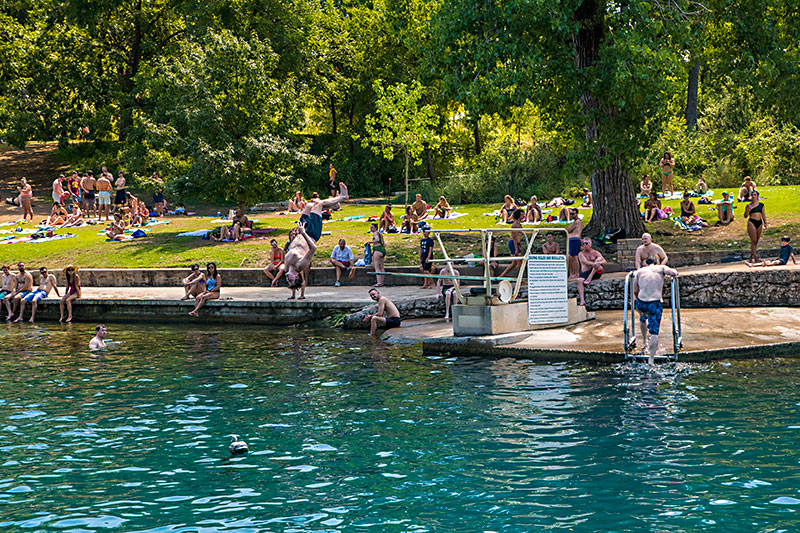
A secondary benefit of the program includes providing habitat for some endangered species as well as monarch butterflies (when WQPL staff discover any endangered species, they amend their plans for prescribed fire and other mechanical interventions). And Watershed Protection says that because the WQPLs reduce the amount of impervious cover that would be present on developed land in the form of parking lots, roads, and residences, they also reduce the volume of floodwater during heavy rains and the duration of high water levels from certain creeks like Onion, Bear, and Slaughter. Watershed's hydrogeologists, in partnership with the Barton Springs/Edwards Aquifer Conservation District, continue to conduct studies where they put colorful dyes in the water of caves and creeks, which comes out unfiltered at Barton Springs in a matter of days, sometimes traveling as fast as seven miles per hour because the aquifer is made of porous dissolved limestone. "It is the karst nature of the aquifer," Thuesen says. "That means the only way water can get in is through cracks, sinkholes, and dissolved pores or conduits, whether they be on the surface or under creeks," Thuesen says. By this point, we're at Barton Springs Pool, standing near the diving board, the sounds of people talking and water splashing in the background. Thuesen points to some rocks along the eastern edge and explains that this is where water pours out of the aquifer and into the pool. He then says with an impressed smile, "Everything that we saw today is just so the water can get underground – and it's cooling off as it's traveling – and come out here."
Soul of the City
The original mission of the WQPL program included improving the quality and quantity of Barton Springs water as well as Austin's drinking water. This is why the first two bonds were utility bonds. But in 2008, the city stopped using the Green plant, located in the Seaholm District along Lady Bird Lake, and now gets its drinking supply from lakes Austin, Travis, and Buchanan. Slusher, who became the Water Utility's assistant director for conservation in 2007, says there are plans to eventually have a plant downstream of Tom Miller Dam, which would use some Barton Springs water, but this is not currently in the works. While about 60,000 people in between Barton Springs and Kyle rely solely on wells tapping into the Edwards Aquifer, most of them live outside Austin city limits.
Come November, voters will decide on seven different bond propositions totaling nearly $1 billion. The WQPL item is found in Proposition D, which is pretty vague and doesn't talk about the program or Barton Springs. It mentions "acquiring land, open spaces and interests in land and property" for flood and erosion control, water quality and quantity, and stormwater drainage. $72 million of Prop D's $184 million would go to the WQPL program while the remainder would go toward drainage and stormwater projects. The city has published a brochure informing voters about the bonds, and does a better job of explaining them. (Though it mentions the Colorado River as being impacted, this is a somewhat small aspect considering that a number of tributaries feed the river.) The entire bond package is being championed by a range of groups, from the Austin Board of Realtors to the Barton Springs Conservancy. The Greater Austin Chamber of Commerce is not supporting Prop D because, if passed along with the other propositions, it would play a role in raising the property tax rate.
Though Hays County was initially concerned about the WQPLs because Austin was buying land in its jurisdiction that would be owned by a non-taxable government entity, it seems that the issue has fallen off its radar as nobody was available to respond to my questions. Past resistance to the program has centered on the low level of public access allowed on the lands; just two public trails exist on all 28,000 acres. And because they're meant to preserve the land and water quality, these will never be enjoyed, nor used, to the extent that the Barton Creek Greenbelt is. Local runner Carie Hajek, who frequently visits the Slaughter Creek Trail, says this is exactly what makes it special. "What I love about it is the wildlife and that it's so quiet," she says. "It's taught me quite a bit about how the water travels through our system." Groups like the Texas Equestrian Trail Riders Association say they recognize that recreation is not the primary mission of the lands, and Kent Browning of the Austin Ridge Riders Mountain Bike Club says he supports the bond but hopes some of the new lands will be appropriate for public usage.
Public access is about to increase with the completion of the Hill Country Conservancy's 30-mile Violet Crown Trail, which starts at Zilker Park and goes through parts of the Barton Creek Greenbelt and south through Sunset Valley, and will eventually go past Slaughter Lane to the Lady Bird Johnson Wildflower Center and onto the WQPLs owned outright by the city. The first phase is expected to be complete by spring 2020, and the second phase's finish date is to be determined. Thuesen says that if this is done right, it could be a good thing, but it also risks harm from increased usage. To teach users how to be "good stewards of the land," CEO George Cofer says HCC, which also supports the bond, will ban dogs from WQPL portions and will include educational experiences about the land and aquifer recharge. HCC will take caves and other sensitive areas into consideration and will have a trail that is a narrow dirt path instead of the wider trails made of stabilized crushed granite on other portions.
So is land that doesn't currently impact drinking water and isn't widely open to the public worth tens of millions of dollars? The answer to this depends on how much our city values Barton Springs. All previous WQPL bonds have been approved by citizens, with 53-68% of the vote. Because city staff can't advocate for or against bonds, I ask Bunch for his thoughts, and he responds that the bond is necessary and that the springs are still relevant. "I think the awareness of what Barton Springs means to the city has changed but what it means to the city has not," he says. "With our booming population, we have very limited access to nature, and access to nature is essential to mental and physical health. We've seen the attendance at Barton Springs absolutely explode over the last 10 years with people recognizing that it's an incredibly beautiful, restoring, healing bit of nature delivered into the heart of the city by virtue of an underground river through the limestone rock of the Edwards Aquifer."
Got something to say on the subject? Send a letter to the editor.