![]()
https://www.austinchronicle.com/news/1998-12-04/520745/
Our Little Town
Travis Heights Arrives
By Mike Clark-Madison, December 4, 1998, News
The school adjoined Charles Newning's Fairview Park subdivision, the second of three neighborhoods that compose what we now call "Travis Heights." Their stories are instructive. The first, the Swisher Addition, was first platted in 1877 on both sides of South Congress, which tells you just how unprepossessing a commercial drag the Avenue was before the new bridge. (The eastern half stretched around the School for the Deaf to then-unnamed South First Street, and has now been annexed to Bouldin.)
Though the Swisher Addition, with its streets named for various Swishers (Monroe, Mary, Johanna, Eva, et cetera), and similar projects around it were never intended to be grand, downtown hopes for South Austin's fortunes were so high that many parcels were snapped up as investments by wealthy Austin families. When Charles Newning, the agent for a New York bank, came to town in 1878, he saw the need for an upscale, owner-occupied "garden suburb," of the type then trendy in the East, where those same families would actually live, and bought 200 acres northeast of the Swisher Addition for Fairview Park.
Today, Fairview Park is the "rambling" part of Travis Heights - indeed, one of the streets was called "The Ramble" (it's now Park Lane), along with The Circle, which in Newning's plan was actually a circle. Newning envisioned large houses on large lots, installed the utility infrastructure himself, and divided his tract into irregular portions to accentuate each homesite's "picturesque" natural elements.
This is all standard today, but at the time most subdivisions relied on standard grids with regular lots, left sidewalks and sewer hookups to the owners, and made no attempt at income segregation. For example, the Doughty Addition, a three-block development platted in 1890 east of Congress and south of the Swisher Addition, advertised thus: "Homes for the laboring men! No city taxes! Homes for the young couples! No city taxes! Elegant suburban places for active and retired business men! No city taxes!" (Two of the larger lots, intended for those business men, would later become Cinema West.) Still, by the time most of the lots were sold, the city taxes had arrived.
Ultimately, Newning took a bath on Fairview Park, partly because the Austin gentry preferred neighborhoods that didn't require a river crossing - by 1900, the Congress Avenue bridge had become the state's most notorious traffic bottleneck, and would remain so until the erection of the Montopolis (1938) and Lamar (1941) bridges. That traffic was a boon to businesses along South Congress, which was in turn good for less pretentious neighborhoods like the Swisher Addition. But Newning's ambitions for an elegant enclave were doomed by the growth of the adjacent South Congress strip; it wouldn't be until the 1940s that Fairview Park, by that point substantially altered and downscaled, would be completely built out.
It fell to Newning's partner, Gen. William Harwood Stacy, and later his sons Harwood and Gillespie Stacy, to create a successful uppity Southside neighborhood with Travis Heights proper. This was unquestionably the most heavily promoted neighborhood of its time, the Circle C Ranch of pre-WWII Austin, with ads in nearly every edition of the papers bearing the classic slogan: "Out of the Noise-Zone and Into the Ozone."
The Stacys learned from Newning's mistake and equipped the Heights with a few small lots to accommodate selected members of the working class, along with some of Austin's first deed restrictions. "Travis Heights is restricted to good homes, good people, and strictly residence purposes," read one 1917 prospectus. "You are guaranteed against the encroachment of undesirable buildings, or disagreeable business or manufacturing enterprises. ... If you value your children's well being, get them a home of your own and get it quick ... as far away from business and the fever and sham of transient life as possible. Make it the center of their interests and pleasures, and the downtown attractions will never lay a strong hold upon them."
City Within a City
Of course, the Stacys' vision of suburban splendor would have gone nowhere were the "downtown attractions" not right across the river, easily accessible by foot, car, or streetcar, and clearly visible from the Heights. And while Travis Heights was quite the hit, it didn't lead to a wholesale boom along the South Shore. West of Congress remained a largely rural preserve until WWII, even though subdivisions like the Bouldin Addition (which, like Travis Heights, was only one segment of the neighborhood that bears the name today) were platted before WWI. Once you got as far west as the Fredericksburg Road (today's South Lamar Boulevard), the subdivisions themselves disappeared - except for Barton Heights, core of today's Zilker neighborhood.
|
|
These areas didn't really fill in until the First Street and Lamar bridges were erected, and as with South Congress, growth came first to the commercial corridors. Even before then, though, Austinites talked of a South Austin boom, especially when the last devastating Colorado flood of the pre-LCRA era, in June of 1935, laid waste to most of the low ground on the South Shore. "The business houses that were destroyed," noted the Statesman in 1936, "have been replaced by bigger, more attractive structures." Even amidst the boosterism, it was clear to the Statesman that "South Austin gradually is becoming a distinct community despite its importance as an integral part of the whole city."
Following the Stacys' example in Travis Heights, developers emphasized the Southside's quietude and scenic isolation, even as the newly widened, paved, and straightened major corridors guaranteed it would remain quiet and isolated no longer. For example, South Congress used to dead-end into an addition called LaPrelle Place, near today's intersection with Oltorf. As late as 1930, LaPrelle Place was marketed as a Travis Heights-like garden suburb with all mod cons, including the ever-valuable city water service, but no city annoyances. But in 1934, the city got the state to pave and widen South Congress through LaPrelle Place, knocking out a substantial chunk of the development, to connect with the new San Antonio highway.
Neglect Sets In
The South Austin legend holds that city leaders have always neglected and shortchanged the Southside, but this alone doesn't explain the sluggish pace of growth. Additions in the north, much farther from downtown and with fewer amenities, filled in almost as fast as their developers could plat them, while projects like LaPrelle Place and Bouldin, more than 20 years old by the 1930s, were barely more than lines on a map. Even when the city did pour resources into South Austin - utilities, new roads, streetcar service, new schools, and parks - the area failed to move.
For example, witness the saga of Zilker Park, especially through modern-day eyes. It's curious that, when "destination parks" were touted in the last bond package as a way to spur growth in specific areas, Zilker was cited as a precedent, when in fact the park's saga was quite different: The city built it out quickly, spent a lot of money on it, and still saw no great explosion of development nearby.
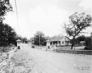
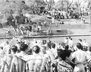
When the city bought Barton Springs and more than 40 acres of surrounding property from Col. Andrew Jackson Zilker in 1917 for $100,000, it was already a popular attraction, and both the pool and the bathhouse were remodeled and expanded several times between then and the development of Zilker Park itself. None of this public investment and traffic had much effect on nearby property, though at least some city elders saw the Springs as a potential hub of an extensive tourist district à la Hot Springs, which is why they supported the purchase in the first place.
Much land around the Springs was still owned by old man Zilker himself, who had made his fortune as Austin's leading ice merchant and then diversified into the brick business, for which purpose he had bought the clay pits that form most of today's park. By 1932, when the city came back asking to buy more land, Zilker - who never actually lived in South Austin - was rich and locally famous, a former president of the school board, and he decided to give the city his nearly 300 acres outright. Within 18 months, with the assistance of Depression-era work relief agencies, Zilker Park was opened to the public, on July 4, 1933, with elaborate amenities remarkable in scale for a city Austin's size.
Again, civic leaders saw Zilker Park as not just an Austin public service but as a regional attraction that would transform the sleepy Southside. And again, much of the land around, and on the way to, Zilker Park was to remain sleepy for years and decades thereafter. Whether it was the Armadillo, the used-car lots and shanties replaced by Palmer Auditorium, the pecan grove that became Restaurant Row, or vacant lands and failed subdivisions that were eventually merged into the park, the whole Barton Springs corridor was dominated by what the planners call "marginal uses" until the modern era.
Image Is Everything
What does this all mean? The most plausible argument is that the long-running image of South Austin as a bucolic Bubba backwater, where Homo Austinus lives in his primitive state, has proved far more powerful than the facts on the ground, and has thus changed South Austin reality. And that can only really be explained if you concede that the image is at least partly self-defined - or self-inflicted, depending on your dreams. If the Northside and downtown elite were fixated on making South Austin part of a whole city, then who was it who pushed in the other direction? The Southsiders themselves, the literal and spiritual descendants of the Stacys' customers in Travis Heights who wanted to be separate and distinct.
|
|
It's tempting to say that South Austinites have, after years of maltreatment, internalized their supposedly stigmatized status and made it a badge of pride, but the fact is, it's always been this way, from the pre-bridge Southside's self-identification as the "Brooklyn of Texas." By 1954, even the kids had gotten into it; in the first Travis High School yearbook, students thanked "the citizens and businesses of South Austin" for building the school, as if the rest of Austin's citizens and businesses played no part.
And, of course, today we have "78704 - a way of life" bumper stickers, and semi-serious calls for South Austin secession, all rooted in the Southside's rebel-yell, home-with-the-Armadillo mystique. This is even true in neighborhoods like Barton Hills and Travis Heights, which have from their inception been as chichi and desirable (and jealously protective of their desirability) as any district north of the river.
And the neighborhoods in between, while nowhere near as boutique, have never been any more po' than dozens of neighborhoods elsewhere in the city. Indeed, if there was ever a time when the Inner Southside was truly Bubba, it was fairly short-lived, and whatever the 78704 way of life is today, it doesn't have much to do with the South Austin stereotype of cheap rents, rednecks, and the widespread availability of alcohol and fried foods.
But surely the self-spawned notion of South Austin as a separate place has lived long, and will die hard. Indeed, it has grown stronger even as the real-world South Austin becomes less and less distinctive. The Colorado River may have been tamed, but in the minds of Austinites it still runs wild, dramatically dividing the city in twain and continuing to carve the Southside landscape.
Copyright © 2024 Austin Chronicle Corporation. All rights reserved.